
Winter is one of the best times to get outdoors in Cape Town. Cooler temperatures, lush green landscapes, flowing waterfalls, and crisp, clear days create ideal conditions for hiking across the city. Whether you’re after a gentle nature walk, a family-friendly adventure, or a rewarding climb with spectacular views, Cape Town’s incredible network of free trails has something for every explorer.
Lace up your boots, grab a jacket, and make the most of the season. Here are some of the best free hikes and nature walks in Cape Town to enjoy this winter:
Alphen Trail
Distance: Between 3-8 km
Difficulty: Easy
If you’re looking for an easy or moderately challenging route, the Alphen Trail is an excellent choice. Popular with walkers and runners alike, the trail is likely to bring you past a few friendly faces along the way. Accessible year-round, the trail is especially beautiful in winter, when crisp air and shifting foliage colours bring the landscape to life. Dogs are welcome on leads, making it an easy outing for pet owners. Along the way, take in the peaceful scenery of towering trees and streams. Once you have finished your walk, enjoy a coffee from a nearby vendor and relax on a bench while soaking up the serene surroundings.
View the map here.
Woodstock Cave, Table Mountain
Distance: 6.4 km
Difficulty: Easy (has some steep inclines as you hike up)
After good rainfall, the small waterfall at Woodstock Cave on the slopes of Table Mountain becomes a striking curtain of water. From the cave, you are rewarded with sweeping views across the city. This relatively easy, family-friendly hike can be enjoyed in all seasons. There are two main starting points for the hike. One option is via Tafelberg Road. Drive past the Cableway station and park near the start of the Woodstock Cave route. Alternatively, you can begin at Rhodes Memorial and make your way up to the King’s Blockhouse. From there, continue beyond the Blockhouse until the path splits. Take the left fork, then at the next junction turn right towards the Cableway.
View the map here.
Deer Park
Distance: 4.7 km
Difficulty: Moderate to challenging
Short on time? This 90-minute hike is easy to navigate and perfect for a quick escape into nature. The park is popular with hikers, runners, and mountain bikers, so you will likely share the trail with plenty of other outdoor enthusiasts. It is also dog- and family-friendly, making it a flexible option for a relaxed outing close to town. Along the way, you will enjoy views of Table Mountain and the city skyline. Finish your walk with a stop at Deer Park Café for a well-earned treat.
View the map here.
The Pipe Track, Table Mountain
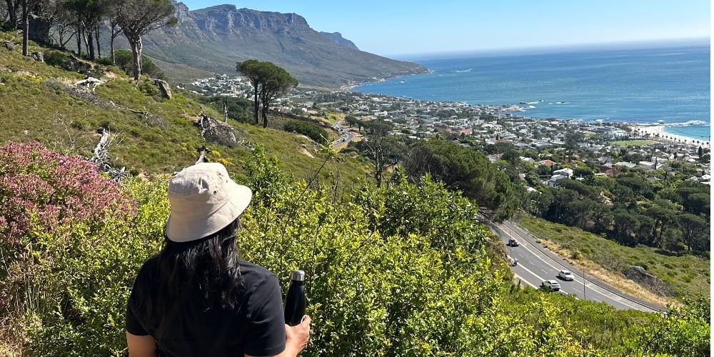
Distance: About 6 km
Difficulty: Beginner-friendly
If you’re after an easygoing hike with big views, the Pipe Track is a winner. One of the most accessible routes on Table Mountain, the Pipe Track is mostly flat, with just a few stone steps to get your heart racing. The trail begins at the corner of Tafelberg Road and Kloof Nek. Park at Kloof Nek, climb the steps with the fence on your left, and you will soon spot a signpost and trail map at the base of Kasteelspoort. That is your cue to hit the Pipe Track. From here, it is all about soaking up the scenery. You will wind along the edge of the mountain, with sweeping views of Camps Bay, Lion’s Head, and the Atlantic stretching out below. The trail takes you through a series of lush ravines, with plenty of scenic spots to pause for a water break or a few envy-inducing photos.
View the map here.
Cecilia Forest Waterfall

Distance: 4.3 km (return)
Difficulty: Moderate to challenging
Just south of Kirstenbosch National Botanical Garden, you’ll find the beautiful Cecilia Forest in Constantia. Wander along the slopes of Table Mountain, with views of the southern suburbs stretching to Muizenberg, and discover an enchanting waterfall along the way. Start and finish the hike at the Cecilia Forest car park, off Rhodes Drive in Constantia. Follow the contour path and signs to Cecilia Ravine via Rooikat Ravine. The hike involves some climbing, so wear sturdy shoes, a hat, and bring plenty of water. The trail is open year-round, and dogs on a leash are welcome.
View the map here.
Lion’s Head

Distance: 5 km
Difficulty: Moderate
No list of Cape Town hikes would be complete without Lion’s Head. This iconic peak offers 360-degree views that are well worth the climb, with the city, the ocean, Table Mountain, and even Robben Island laid out below. The hike starts just off Signal Hill Road and takes about 90 minutes to two hours, depending on your pace (and how often you stop to snap photos). The trail spirals around the mountain, offering ever-changing views, before a short but steep scramble to the summit. There are ladders and chains to help you near the top. There’s an alternative footpath if you don’t want to wait for the crowds to climb up.
View the map here.
Winter Hiking Tips
- Check the weather before setting out.
- Don’t hike alone; four is the ideal number.
- Choose your route carefully and stick to it. Allow enough time – start early. Inform someone of your route and expected return time.
- Always take enough water and food in case of a delay. Watch the weather and the time, and turn back before you run late or if bad weather threatens.
- Stick to well-used paths, which are indicated on the park’s hiking map. Read the warnings on this map. Don’t take shortcuts, especially don’t wander into ravines.
Related Articles
The post Free Hikes and Nature Walks in Cape Town to Try This Winter appeared first on Cape Town Tourism.